With 2,500+ miles of Salish Sea shore, lakes and rivers galore, there are plenty of canoe destinations in the Pacific Northwest

Map Source: USGS
several trail systems
Lake Sammamish to Lake Washingotn to Lake Union to Puget Sound
Plenty of flat water to explore in Seattle
Lakes Sammamish to Lake Washington to Lake Union
Sammamish River/Sough, Mercer Slough and Arboretum
It is possible to do a 50 miler starting in Lake Sammamish and end in Puget Sound in Everett

Map Source: USGS
Lake Challenge is an excellent place to teach scouts the basics of
canoeing. Canoes, kayaks, other watercraft, PFDs, paddles and
campsite are all available.

Map Source: USGS
Hughes Lake is easy is great place to conduct canoe training.
Canoes, kayaks, other watercraft, PFDs, paddles and campsite are all available.

Map Source: USGS
Watercraft can be rented at UW Waterfront Activities Center
www.washington.edu/ima/wac
canoe-boat-rentals
3710 Montlake Blvd NE
Seattle, WA 98195
March – October
UW Alumni: $11.50/hour
General Public: $12.00/hour
Easy waters covered in lily pads
Beaver Dens
Arboretum is surrounded by forested areas, doesn't appear you are in city
NOTE:

Map Source: USGS

Map Source: USGS
50 Miler option
Can enter Canada side or South side
South side requires portage - truck will pick you up and transports watercraft if desired
Portage Service from Diablo Lake to Ross Lake
www.nps.gov/noca/planyourvisit/boating-on-ross-lake.htm

Map Source: USGS
This little gem is a wonderful place to take scouts new to canoeing (after mandatory training of course). There are reservable campgrounds as well as a few canoe in, first come first served sites.
The mini island on the lake has enough room for 20 scouts.
The waterfall is a must see at No Name Creek. Camping is possible there, but it is difficult to set up tents and 12 is probably the max number there (assuming some will use hammocks or other alternative methods to camp).
There is a third group site just south of the cliff wall on the eastern bank just north of the launch site.
Other dispersed camping is possible, but not for large groups.
Afternoon winds will make southern travel challenging for new
scouts. Plan for or avoid windy times.

Map Source: USGS
French Cabin Creek Recreation Area allows for dispersed camping. This allows scouts units to camp out by a canoeable lake.

Map Source: USGS
Big lake option for bigger adventures. There are many campsites along the western and eastern shores of the lake.
fs.usda.gov/Internet/FSE_DOCUMENTS/stelprd3791141.pdf
fs.usda.gov/Internet/FSE_DOCUMENTS/stelprdb5439901.pdf
fs.usda.gov/Internet/FSE_DOCUMENTS/stelprdb5407534.pdf

Map Source: USGS
Put In/Take Out: Luhr Beach
Travel to upper portion of McAllister Creek
Highlights: harbor seals, birds, and maybe a whale
fws.gov/refuge/Billy_Frank_Jr_Nisqually/visit/boating.html
Factor in Tides and don't get stuck:
tidesandcurrents.noaa.gov/noaatidepredictions.html?id=9446828&legacy=1

Map Source: USGS
greater than 12 square miles - Largest Unaltered Natural Lake in Washington
Plenty to explore
Lots of backcountry campgrounds (some are NOT clearly marked)
Minimal boat traffic
Portage not required
Note:

Map Source: USGS
There are many rivers to explore in Western Washington. They range from flat lake-like waters to raging rapids.
NOTE: per www.scouting.org/health-and-safety/gss/gss02/:
Before a unit using human-powered craft
controlled by youth embarks on a float trip or excursion that covers an
extended distance or lasts longer than four hours, each participant should
either receive a minimum of three hours training and supervised practice
or demonstrate proficiency in maneuvering the craft effectively over a
100-yard course and recovering from a capsize.
Self-guided unit trips on Class III whitewater may only be done after all
participants have received American Canoe Association or equivalent
training for the class of water and type of craft involved. Unit trips on
whitewater sections of rivers rated Class IV are only allowed in rafts
with a professionally trained guide in each raft. Trips above Class IV are
not allowed.
Connects Lake Sammamish to Lake Washington
13.0 miles Class "A"
4-5 Hours - Easy
Put-In: Redmond’s Marymoor Park
Take-Out: Washington Department of Fish & Wildlife water access site Kenmore (need Discovery Pass to park)

Map Source: USGS
16 river miles
Put-In: Haller Park in Arlington
Take-Out: Hat Slough boat launch
Concerns:

Map Source: USGS
Fed by the Snohomish River, The Everett Delta has many waterways worth exploring.
NOTE: water levels are heavily influenced by coastal tides. Some waterways are impassible at low tide. Some waterways are extremely difficult to navigate if you are going against the tide. Plan your trips accordingly, ideally with the tide assisting you throughout your trip.
tidesandcurrents.noaa.gov/noaatidepredictions.html?id=9447659&legacy=1
www.usharbors.com/harbor/washington/everett-wa/tides/
Union Slough
7.5 miles
Launch and pickup at Langus Park. Canoes don't need to pay the $10 fee. Just don't take up trailer parking.
Plan your trip in as the tide is rising and peaks ideally in the middle of your trip. Union Slough is impassible at low tide, and you could actually get trapped there if you time it wrong.
If you start with the tide going out, it will be challenging and potentially dangerous for less experienced scouts to make it to Steamboat Slough as they fight the current. Once you get to Steamboat and Union Sloughs, the water is gentle and hardly moves. Enjoy the meandering route of Union Slough and the collection of boats on Steamboat Slough. Plan 6 hours for this trip. It can easily expand past that if you explore drainage canals in Spencer Island or have zigzagging scouts who tire quickly.
In the past - it took us 8 hours fighting the tide both ways, exploring every drainage canal, goofing off on the beach and having to backtrack because of low tide in Union Canal. Better timing and better experienced scouts could cut that time in half.
Map Source: USGS
Other routes are worth exploring for more experienced groups. Just take the tide into account.
Launch Points:
Sloughs in Everett Delta allow you to mix up your route a bit.
Consider tides when planning your trip. Tides can make it easier or more difficult to navigate the delta. Incoming tides will make it more reasonable to start your trip going upstream. Outgoing tides will make upstream travel pure torture.
www.usharbors.com/harbor/washington/everett-wa/tides/
Snohomish River Boat Launch to Lowell Boat Ramp - 6 miles
Snohomish River Boat Lauch to Langus Park Boat Ramp - 10.5 miles
Map Source: USGS
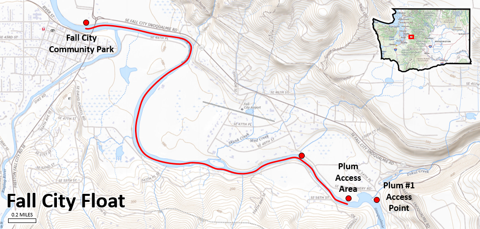
Snoqualmie River Tubing
Plum Boat Launch to Fall City Park: www.outdoorproject.com/united-states/washington/snoqualmie-river-float
Discovery Pass required for Plum Access Area
3.3 Miles
2.5 to 4 hours of float time based on water levels
Map Source: USGS
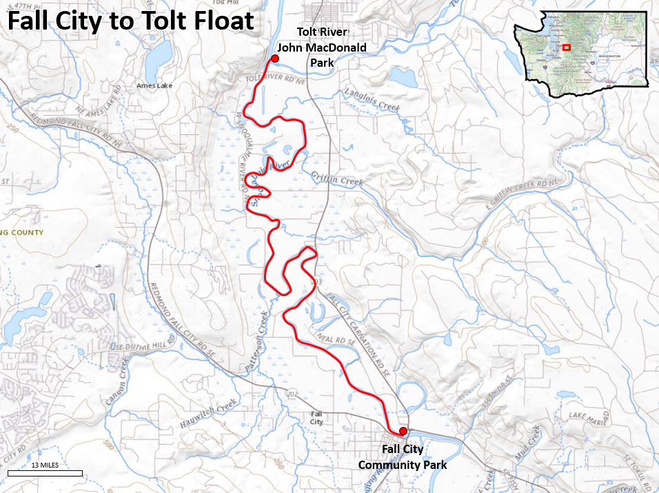
Fall City Park to Tolt-MacDonald Park Float
10 mile Float
All Day Float
Map Source: USGS
Skagit - I(II)
Difficulty I(II)
Length 49 mi
short day trips or multi-day adventures

Looking for something more exciting than flat water?
NOTE: per www.scouting.org/health-and-safety/gss/gss02/:
Before a unit using human-powered craft
controlled by youth embarks on a float trip or excursion that covers an
extended distance or lasts longer than four hours, each participant should
either receive a minimum of three hours training and supervised practice
or demonstrate proficiency in maneuvering the craft effectively over a
100-yard course and recovering from a capsize.
Self-guided unit trips on Class III whitewater may only be done after all
participants have received American Canoe Association or equivalent
training for the class of water and type of craft involved. Unit trips on
whitewater sections of rivers rated Class IV are only allowed in rafts
with a professionally trained guide in each raft. Trips above Class IV are
not allowed.
Skykomish at Gold Bar (Half Run)
9-mile
Put-In: Big Eddy
Take-Out: Sultan
Class II
beautiful scenery and wildlife
Great Run
Learn how to turn a canoe at Big Eddy

Map Source: USGS
Skykomish - I-II
Big Eddy to Monroe (Full Run)
Difficulty I-II
Length 19.3 mi
Avg Gradient 18 fpm
Option - stop at Sultan for a shorter trip (shown above)
Skykomish - II
Railroad
Bridge to Big Eddy
Difficulty II
Length 3.5 mi
Skykomish, S. Fork - II
Beckler River to bridge above Baring
Difficulty II
Length 11.2 mi
Mellow river float with a few rapids
Suitable for beginners with support from experienced paddlers
Put In: Highway 2 bridge east of the town of Skykomish
where the Beckler and Tye come together to form the South Fork Skykomish
(Highway 2 mile 49.8). You can find parking on the upstream river left
side of the bridge.
Take out: Barclay Creek at mile 40 on Highway 2 or
Bridge at mile 46 on Highway 2
NOTE: unrunnable drops are only half a mile downstream - Know where Takeout is!
Skykomish, S. Fork - II(V+)
Baring to Sunset Falls
Three major waterfalls: Eagle Falls, Canyon Falls, and Sunset Falls
Note: several fatalities along this stretch of river particularly during summer with swimmers or tubers who didn't realize the danger of the falls
Beckler - II-III
Rapid River to S.Fork Skykomish
Skykomish - III+(IV)
Index
(Sunset Falls) to Split Rock
Silver Creek - IV-V
Quartz
Creek to North Fork Skykomish
Skykomish, N. Fork - IV
Bear
Creek (Drumb-beater) to South Fork confluence
Skykomish, N. Fork - II-V
Jackson
Wilderness to Bear Creek
Stillaguamish, N. Fork - II
Moose Creek to Oso
Stillaguamish, S. Fork - II
Granite Falls to Jordan (Lower)
Stillaguamish, S. Fork - II+
Deer
Creek to Mallardy Creek (Upper)
Stillaguamish, S. Fork - III+
Mallardy
Creek to Verlot (Middle)
Stillaguamish, S. Fork - V
Verlot
to Granite Falls (Robe Canyon Run)
Stillaguamish, N. Fork - V
Confluence
with S. Branch to bridge below Moose Creek
Snoqualmie, Middle Fork - II
Taylor River to Concrete bridge (Upper)
Snoqualmie, Middle Fork - II
Tanner to North Bend (The Club Stretch)
Snoqualmie, S. Fork - II+
Twin Falls State Park to 436th St. Bridge
Snoqualmie - II+
Snoqualmie Falls to Plum's Landing (Powerhouse)
Snoqualmie, Middle Fork - II-III(IV)
Burnboot Creek to Taylor River
Snoqualmie, N. Fork - III
Big
Creek to Spur 10 Bridge (Upper)
Snoqualmie, N. Fork - III+
Sunday
Creek to Wagner Bridge
Snoqualmie, Middle Fork - III-IV
Concrete bridge to Tanner (Middle-Middle)
Snoqualmie, S. Fork - IV-V
I-90 Exit 52 to Denny Creek Campground (Fall in the Wall)
Snoqualmie, Middle Fork - V
Hardscrabble Creek to Burnboot Creek
Snoqualmie, N. Fork - V+
Spur 10 Bridge to 428th St. Bridge (Ernie's Gorge)
Machias to Snohomish
Difficulty II
Length 6.9 mi
Avg Gradient 15 fpm
Beginner run
bike shuttle option on Centennial trail
Tolt - II
Difficulty II
Length 5.2 mi
Tolt River Road nr. Carnation to Snoqualmie River
Generally a few log jams
class II gravel bar rapids start from the confluence of the North and South Forks of the Tolt
Difficulty II
Length 19 mi
Landsburg bridge to Maplewood Roadside Park
Cle Elum - II
Cle Elum Dam to confluence with Yakima River
6 miles 1,200 – 4,000 cfs
Cle Elum - II
Salmon La Sac Creek to Cle Elum Reservoir
Cooper River - IV-V
Waterfall
to Cle Elum River
Cle Elum - IV-V
Scatter
Creek to Salmon La Sac Creek (China Gorge)
White - II
Difficulty II
Length 14.5 mi
Avg Gradient 32 fpm
Because of wood hazard in middle third of route, this is not the best beginner run and you can expect to portage a couple times
Best rapids are in first 1/3
OK rapids final 1/3
White Salmon - II-III+(V)
Buck
Creek to Columbia River (Lower Gorge)
White Salmon - III+(V)
Class III+, 7 miles
500 – 2,000 cfs
White Salmon - III-IV(V)
Cascade Creek to Trout Lake (Mt. Adams Section)
White Salmon - IV-V
Trout Lake to Green Truss Bridge (Farmlands)
White Salmon - V
Green Truss Bridge to BZ Corners
Little White Salmon - V
Nisqually - II
Mashel
River to Mckenna
Nisqually - V
La
Grande Reservoir to Mashel River
Deschutes - II
Difficulty II
Length 10.5 mi
Note: there is also a a Deschutes River in Oregon
860 Trailhead Rd, Olga, WA 98279
Outhouses
parks.state.wa.us/553/Obstruction-Pass
non-power boat access.
Orcas Island ferry.
Jackson Cove on the Puget Sound is a option for salt water trips
Canoes, kayaks, other watercraft, PFDs, paddles and campsite are all available.
Greater Columbia Water Trail - wenatcheepaddle.org/Columbia-River-Trails_home.cfm
Travel planning is challenging with Scouts and mixed adult groups
1.5 miles per hour on flats
Max 4-5 hours
On rivers - plan for float travel - time it takes if scouts don't paddle
3 miles per hour
Max 20 miles
Max 7 hours
Rivers? - flow plus 2-3 miles per hour
Scouts and most adults should only be in tandem canoes with 2 paddlers
Set up buddy teams. If a scout buddy doesn't make the trip, that canoe is grounded. It's unfair, but safer than trying a solo experiment.
Solo canoes can't keep up with tandem canoes. The exception is when
you have an experienced adult and a younger scouts.
Winds and tides will slow things to a halt or may actually push some boats in the opposite direction.
tidesandcurrents.noaa.gov/tide_predictions.html?gid=1415
www.usharbors.com/harbor/washington
Portage takes a lot of time
Just getting in and out of the canoes takes up a lot of time for scouts